Previous Log "Google Voice" |
Next Log
"India - London Trip" |
Grand Canyon Trip Option #1
July 31, 2009
This is a rim to rim option #1, looking at a few ideas, this one is nice, but a little more heavily traveled so... looking for less people, more strenuous and longer... This hike is 20 miles one way, so 40 for the back to back journey.
Grand Canyon National Park: Rim-to-Rim via South Kaibab Trail
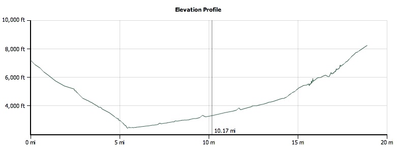
This 18.9-mile route starts at South Kaibab Trailhead on the Grand Canyon's South Rim and immediately descends into the belly of the Grand Canyon on South Kaibab Trail. Along the way, the route passes O'Neill Butte, Skeleton Point, and breathtaking views of the surrounding canyons. At the bottom, cross Black Bridge, a suspension bridge over the Colorado River, and head west to Phantom Ranch and the mouth of Bright Angel Canyon. The route winds to the north up this pinched canyon for 8.7 miles, crisscrossing Bright Angel Creek numerous times. After 14.8 miles, you'll catch the first views of the North Rim as you pass Roaring Springs and enter Roaring Springs Canyon. The trip finishes with brief stretch through the Supai Tunnel—a 20-foot-long hole-in-the-rock wall—and a steep switchback climb to the top of the North Rim.
Elevation Map

TO TRAILHEAD: Start (South Rim): From S. Lake Powell Blvd. and US 89 in Page, AZ, head southwest on US 89. In 81.5 miles, turn right onto AZ 64. In 53 miles, turn right onto S. Entrance Rd. In 2.7 miles, turn left onto Village Loop Dr. In 0.2 mile, bear left at Village Loop Dr. In 0.2 mile, turn right to stay on Village Loop Dr. In 100 feet, turn left to stay on Village Loop Dr. Go 500 feet and park in Lot E at the South Rim Backcountry Information Center. Take a free shuttle bus to the trailhead (check times at Ranger Station). End (North Rim): From S. Lake Powell Blvd. and US 89 in Page, AZ, head southwest on US 89. In 23 miles, turn right onto US 89 ALT. In 55 miles, turn left onto AZ 67/North Rim Pkwy. (closed seasonally). Follow 41.6 miles to trailhead parking on left.